Abraham Ortelius
Flemish (Antwerp, Habsburg Netherlands), 1527 to 1598
Cartography · Copperplate engraving
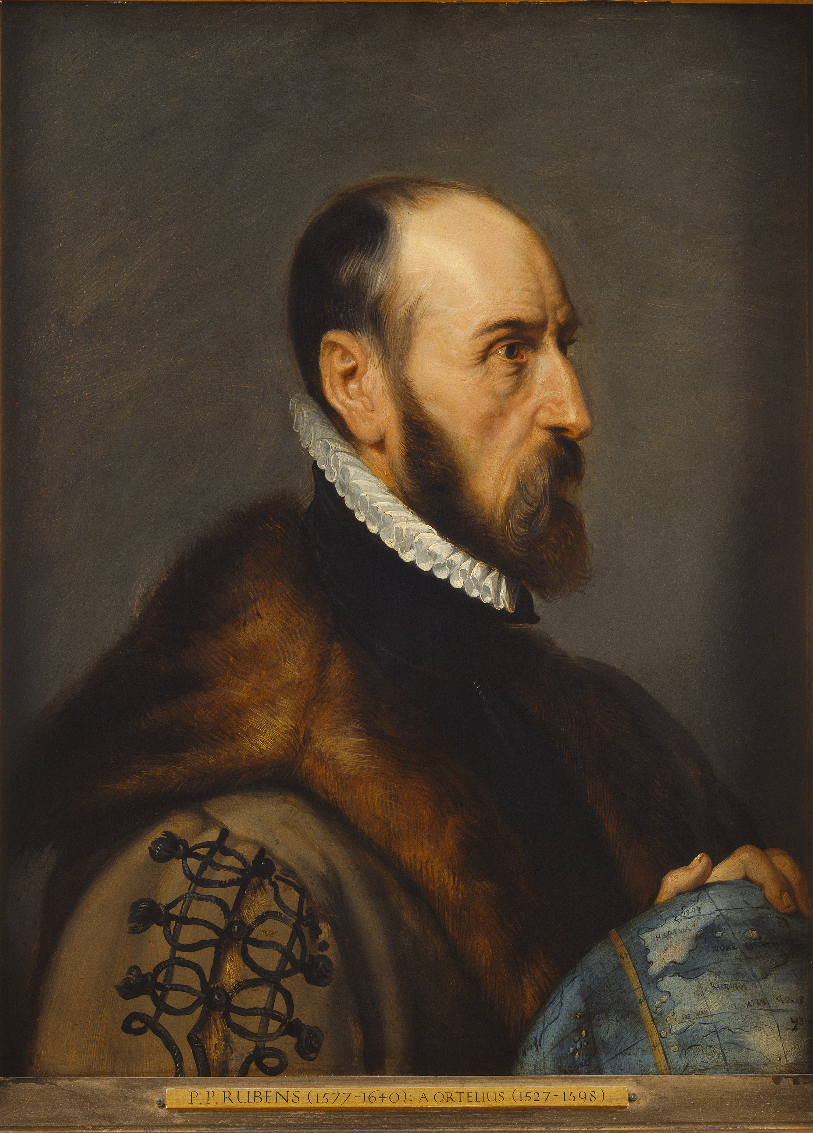
Why Abraham Ortelius matters
Abraham Ortelius is the Antwerp geographer credited with producing Theatrum Orbis Terrarum in 1570, the work historians of cartography generally regard as the first modern atlas. He matters to collectors not as a painter but as the central figure of the Netherlandish school of mapmaking, alongside Gerardus Mercator, and his maps and atlas volumes are enduring holdings in national libraries and museums rather than gallery inventories. For collectors of antiquarian material, his name marks the boundary between medieval mapmaking and the modern, systematically organized atlas.
- Nationality
- Flemish (Antwerp, Habsburg Netherlands)
- Media
- Cartography, Copperplate engraving
- Movement
- Renaissance cartography, Netherlandish (Antwerp) school of mapmaking
- Education
- No confirmed university degree. Educated privately in Antwerp, studying with his uncle Jacob van Meteren and then, largely on his own, Greek, Latin, and mathematics. Entered the Antwerp Guild of Saint Luke as an illuminator and colorist of maps in 1547.
- Signature motifs
- "Theatrum Orbis Terrarum world atlas", "Hand-colored copperplate maps"
By the numbers
- Theatrum Orbis Terrarum, 1570First modern atlasMore than forty editions published by 1641
- USD 6,325Auction high (best documented)Maris Pacifici map, Old World Auctions. Exact sale date and all-time-record status could not be confirmed.
- Royal Geographer to Philip II of Spain, 1573Royal titleAwarded following the success of Theatrum Orbis Terrarum
- Antwerp Guild of Saint Luke, 1547Guild entryRegistered as an illuminator and colorist of maps
Selected works
Click any work to view it full screen.
Biography
Ortelius was born in Antwerp in April 1527. Sources disagree on the exact day, with major references giving either 4 April or 14 April, so this profile treats the day as unresolved. He was educated privately in Antwerp, studying first with his uncle Jacob van Meteren and then, largely on his own initiative, Greek, Latin, and mathematics. No reliable source documents a university degree. A later, secondary account claims he spent time at Oxford around 1551 for study, but this is an isolated, uncorroborated anecdote and is not treated here as confirmed.
In 1547 he entered the Antwerp Guild of Saint Luke as an illuminator and colorist of maps, and he went on to work as a map and book dealer as well as an engraver and publisher. He traveled through parts of Europe and built a wide network of humanist and scientific correspondents, including Mercator. In 1570 he published Theatrum Orbis Terrarum, a uniformly sized, systematically arranged collection of maps that set the template for the modern atlas; it went through more than forty editions by 1641. Its success led to his appointment as Royal Geographer to King Philip II of Spain in 1573. Ortelius is also credited by some historians as an early source for the idea that the continents were once joined, a notion later associated with plate tectonics.
He died in Antwerp in 1598. Reference sources again disagree on the exact day, citing either 28 June or 4 July, but they agree on the year and on Antwerp as the place of death. He was buried in the church of St. Michael's Abbey in Antwerp.
Critical reception
Reference works have treated Ortelius as a foundational figure in Western cartography since at least the early twentieth century. The 1911 Encyclopaedia Britannica entry on him, unsigned, ranked him among the greatest geographers of his age, second only to Mercator. The Catholic Encyclopedia (1913) likewise describes him as a devout Catholic with close ties to the Jesuit order. Modern institutions continue to frame him primarily through Theatrum Orbis Terrarum's role in standardizing the atlas format, and specialist exhibitions at venues such as MAS Antwerp, the University of Missouri Libraries, and Northeastern University Library have kept his work in ongoing curatorial circulation, though exact exhibition dates for these shows were not confirmed in research.
Market
Ortelius's works trade in the antiquarian map, atlas, and rare book market rather than through the fine-art gallery system, and no current gallery or estate representation could be identified. The highest price located in research for a work attributed to him is USD 6,325, paid for the map Maris Pacifici through Old World Auctions; the exact sale date and whether this is in fact the all-time auction high for Ortelius could not be confirmed from available sources. Individual maps drawn from his atlas also circulate as single sheets, sold by specialist dealers and by the travel, atlas, and natural history departments of major auction houses including Sotheby's and Christie's, at prices that vary widely by edition, completeness, and hand coloring.
Top auction results
| Work | Price | Sale |
|---|---|---|
| Maris Pacifici (quod Vulgo Mar del Zur) cum Regionibus Circumiacentibus, Insulisque in Eodem Passim Sparsis, Novissima Descriptio | USD 6,325 | Old World Auctions |
Selected exhibitions
| Years | Exhibition | Venues |
|---|---|---|
| Year not confirmed in sources | Abraham Ortelius (1527 to 1598): Under the Spell of Classical Antiquity | MAS, Museum aan de Stroom, Antwerp |
| Year not confirmed in sources | Places in the World: Treasures from the Venable Collection of Maps (Ortelius section) | Special Collections, University of Missouri Libraries |
| Year not confirmed in sources | An Atlas Is Born, Picturing the World | Northeastern University Library |
Museum collections
- Library of Congress, Geography and Map Division, Washington, D.C.
- University of Michigan Library, Ann Arbor
- St John's College Library, Oxford
- Duke University Libraries, Durham
- Syracuse University Libraries, Syracuse
Awards and honors
- Royal Geographer to King Philip II of Spain (1573)
Authentication and provenance
No catalogue raisonne.
No catalogue raisonne exists. Because Theatrum Orbis Terrarum went through more than forty editions between 1570 and 1641, individual maps and atlas volumes are authenticated by edition, plate state, coloring, and paper rather than by a single artist's catalogue raisonne.
Primary reference: https://www.britannica.com/biography/Abraham-Ortelius
What collectors should know
There is no catalogue raisonne for Ortelius, and because Theatrum Orbis Terrarum was reprinted in dozens of editions over seventy years, verification depends on identifying the specific edition, plate state, paper, and coloring of a given map or volume rather than on a single authoritative reference list. There is no confirmed current gallery or estate representation, so material reaches the market through specialist antiquarian map and book dealers and through the relevant departments of major auction houses. The USD 6,325 Old World Auctions sale of the Maris Pacifici map is the clearest price point found in research, but with the sale date and its rank among all Ortelius sales unconfirmed, collectors should treat it as illustrative rather than as a settled market record, and should expect meaningful price variation between complete first-edition atlases, later editions, and individually sold map sheets.
Further reading and resources
Data current as of 2026-07-16.

